On 19th July, 2018, GeoSLAM, a UK-based company specializing in 3D geographical technology solutions, and 3D Laser Mapping, a leading producer of mobile mapping systems and mapping software, announced that the two companies will be merging.
David Burt, CFO of GeoSLAM, had following to say on the future of the merger: “We are absolutely thrilled to be merging the companies and believe that the combined resources of these businesses will help us to exceed our level of service and support to global customers and dealers.”
Obvious synergies between the two companies will reinforced R&D efforts for 3D scanning technology, and extend their worldwide market reach.
GeoSLAM
GeoSLAM was initially founded as a joint venture between now-merged company 3D Laser Mapping, and Australia’s Commonwealth Scientific and Industrial Research Organisation (CSIRO), that has been crucial to backing future tech opportunities.
Since 2012, GeoSLAM has done some pioneering work in portable handheld 3D scanning equipment, or what it calls “go-anywhere” 3D scanning technologies. It’s latest innovation is the LiDAR scanner ZEB-REVO RT.
ZEB-REVO RT is a lightweight, handheld 3D scanner which offers real-time functionality, meaning that the scan can be viewed in real-time before the survey is complete.
Its real-time functionality, and rotating head, makes it an ideal solution for a lone archaeologist, surveyor, or a 3D scanning enthusiast to access difficult to reach spaces, without relying on extra help or equipment.

3D Laser Mapping
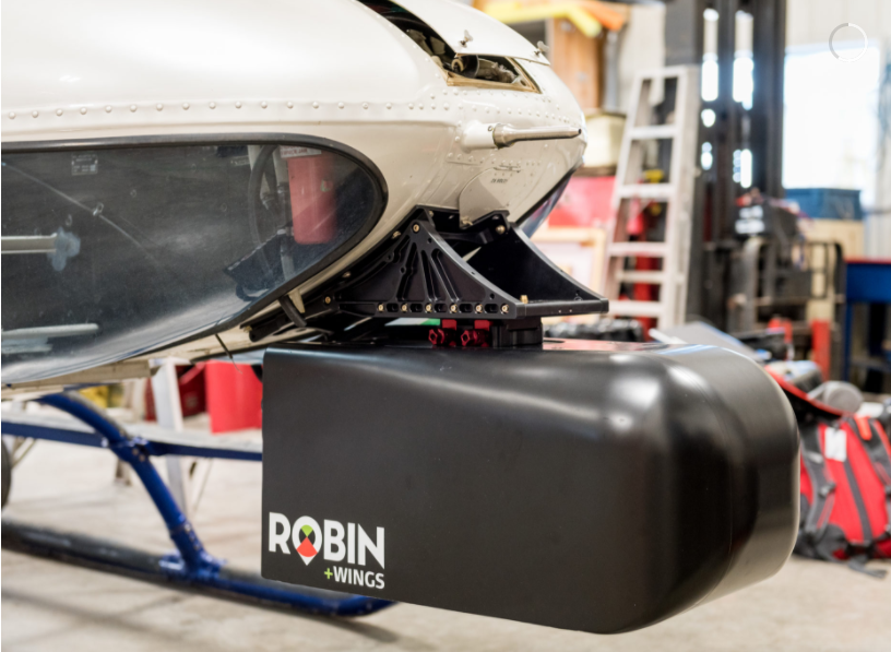
3D Laser Mapping, was established in 1999 in the UK. Its versatile ROBIN, a mobile mapping system, is a portable 3D scanner, typically operated by one person. To produce 3D scans, the operator can scan the environment walking with ROBIN and its backpack, both weighing nearly 10 kg. The scanner can also be mounted to a road vehicle, which offers time-saving solutions in ideal conditions.
Furthermore, ROBIN can make aerial scans of the environment. It can be mounted to UAV, or a helicopter with 3D Land Mapping’s +WING, a lightweight pod, specially designed to integrate with ROBIN systems.
The future of LiDAR
As LiDAR technology continues to find new applications, e.g. teaching autonomous vehicles how to “see”, and preserving global landmarks, it will be interesting to see how the two companies combine their interest to provide better customer solutions.
According to Graham Hunter, founder of 3D Laser Mapping, “This merger will combine the best of the two leading organisations with strong global coverage,”
“They both have very different skill sets with GeoSLAM specializing in global sales, marketing and distribution, whilst 3D Laser Mapping bringing advanced R&D capabilities.”
Combining expertise in market strategies and R&D, the merger hopes to initiate a new era in 3D scanning solutions. Hunter adds, “This will enable the new organisation to supply next generation leading products worldwide.”
In addition to civil engineering and industrial work, both companies are involved in projects related to environmental issues. GeoSLAM has provided geographic mapping solutions for deforestation. 3D Laser Mapping has done coastal monitoring to measure environmental change.
See the latest news on 3D industry, sign up to our newsletter; or follow us on Facebook and Twitter. For 3D industry jobs here.
Featured image shows 3D scan of an electrical grid. Photo via Landpoint.net