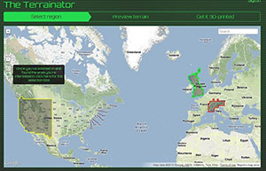
Terrainator is a 3D modelling/printing service from web dev Dan Wilson for all landscape fanatics and other geo-buffs. The basic idea is quite simple – select the location of your choice with the Terrainator from a global (Google) map, zoom in to narrow down the specific area you want reproduced, approve the selection and then just let Shapeways do their magic and take care of the rest.
The result from of the process is a 3D scale model of the area, standing on top of a 50cm² (7¾in²) base. Bigger options are available at a premium. And as for how the materials go, all of the Shapeways standard options are available, but the optimal results are achieved by using sandstone.
Here’s what the process’ basic steps look like in practice from start to finish.

The cost of getting your hands on a Terrainator scale model varies, but the Mont Blanc example in the feature image – with a size of 7.4cm x 6.1cm x 2cm (~2.9” x 2.4” x 0.8”) would be £29 ($43.70 / 33.60€) excluding taxes and shipping costs. Hit the source link for more information.
Source: Terrainator


